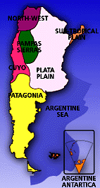
 It is considered a "formal geographical region" a portion of territory characterized by some kind of similitary in its relief, in its climate and in its resources. In the Argentine Republic, we can distinguish eight formal geographical regions.
It is considered a "formal geographical region" a portion of territory characterized by some kind of similitary in its relief, in its climate and in its resources. In the Argentine Republic, we can distinguish eight formal geographical regions.
This region comprises the northeast sector of Argentina. The Pilcomayo, Paraguay and Alto Paraná rivers define its septentrional limit. To the West, the limits are represented by the lower parts of a big western mountainous mass. To the south, the limit is the Colorado river and, to the East, the Aguapey river, the Uruguay river, the river Plate and the Atlantic Ocean.
The big Argentine platense prairie, with 1,200,000 Km2 (465,000 sq.miles), includes the following subregions:
Chaco
It is located in the Northeast part of the country. The limit with the pampeana prairie is gradual. Conventionally it is established along a line that goes from the northern point of the sierras of Córdoba and continues along the river-bed of the Salado del Norte river, to the Paraná river. To the North and East it is limited, respectively, by the Pilcomayo and Paraguay rivers.
Four morphological subunits can be distinguished: High Chaco (soils composed by thick sands and slime), Chaco with depressions (large surfaces where there are swampy lands and marshlands), Low Chaco (clayish and arenaceous soils, lots of marshlands and frequent floods), and Fluvial Diagonal of Santiago del Estero (large marshlands).
Corrientes Swampy Lands
It is a depressed area. It is considered that, as the Alto Paraná was moving to the west, its waters accumulated sediments, mainly arenaceous, in the zones with depressions. Subsequently, the gradual predominance of a drier climatic cycle helped the formation of dunes, wich were fixed by vegetation. When the climate changed again, becoming wet, the low areas between the dunes were filled with water, giving birth to the marshlands. The most important marshlands are the ones of Iberá, Maloyas, Batel and Santa Lucía.
Pampa
The pampa is the southern part of the big platense prairie. It is in the central and eastern zone of Argentina. So it is important to mention that the chaqueńa prairie is of course, the septentrional limit of the pampeana prairie. It is a gradual strip often represented by a line that goes from the northern point of the sierras of Córdoba, to the course of Salado del Norte river, through wich it gets to the Paraná river.
Three subunits are distinguished in the Pampa: Wavy Pampa (territory with slight ondulation, where we can distinguish the cliff, the fluvial terraces and the depression), Pampa with depression (characterized by permanent floods) and High Pampa (saltpetrous lagoons, salt pits and dunes).
Entre Ríos Hills
They go from the septentrional border of the plateau of Mercedes to a cliff which falls abruptly to the deltaica plain. Its limits are, to the East the Uruguay river, and to the West, the Paraná river.
The relief is slightly wavy, the soils have a large quanttity of clay and there are abundant rainfalls.
Deltaica Plain
This region, of about 14.000 Km2 (5,400 sq.miles) is limited by the entrerriana and santafecina-bonaerense cliff, wich are lines of fault that limit a submerged block, occupied by the delta of the Paraná river and the River Plate.
The constant deposit of sediments provided by the Paraná river constitute the origin of the islands, whose shores (ridges of fertile land), slightly high, are sheltered from the normal rising tides. The process of deltification, slow but steady, creates a constant change in the shape and size of the islands.
The Noroeste, traditional name of the northeastern corner of the Argentine Republic, comprises three subunits:
The Puna
It is a large high plateau wich exceeds the limits with Chile and Bolivia. To the South, it goes to the austral hillside of the Sierra de Buenaventura. To the East, from the frontier with Bolivia, it is located on the Escaya and Cochinoca sierras, it continues to the west of the Guayatayoc lagoon, it crosses the Salinas Grandes, San Antonio de los Cobres, the western border of Calchaquí valley, going to the southeast until the Sierra de Buenaventura.
The relief of the Puna is characterized by the presence of a series of plateaus. These plateaus, with an average height between 3,000 and 3,500 meters (10,000 and 11,500 feet), are divided by a strip of sierras, in general of volcanic origin.
Eastern Mountain Range
The western limit is also the eastern limit of the Puna, until Cafayate. From here it goes to the northern point of the Cumbres Calchaquíes and it continues along the Carahuasi, Metán and Zapla Sierras, until it gets to the superior course of the Bermejo River. In the eastern Mountain Range we can distinguish three big morphological units: mountains, streams and valleys.
Subandinas Sierras
They are located between the eastern mountain range and the chaqueńa prairie and composed by short and parallel sierras, directed to the northeast-southeast. The limit is gradual; it is set in the course of the Salí river, including Medina and del Campo Sierras, in the northeast of Tucumán.
Patagonia andina
It is composed by the cordillerana orogeny and it is constituted by ranges divided with valleys and tectonic-glacial depressions, occupied by lagoons. The mountain peaks are covered with glaciers and have rect peaks and sharp needles. The rivers are torrential and respond to two slopes, that of the Atlantic and that of the Pacific.
Patagonia extraandina
It is a plateau formed by continental sea and volcanic sediments over a base. Its morphology is complex, having plateaus of different heights, regions of sierras, depressions and large fluvial valleys. The plateau has large arreicas, endorreicas regions and regions of salt mines. The rivers are formed in the Cordillera de los Andes or in the western plateaus.
| Previous | Home Page | Contact us |